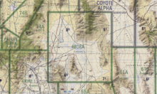
Area 51 is a military base, and a remote detachment of Edwards Air Force Base. It is located in the southern portion of Nevada in the western United States, 83 miles (133 km) north-northwest of downtown Las Vegas. Situated at its center, on the southern shore of Groom Lake, is a large military airfield. The base's primary purpose is to support development and testing of experimental aircraft and weapons systems.[1][2]
The base lies within the United States Air Force's vast Nevada Test and Training Range. Although the facilities at the range are managed by the 99th Air Base Wing at Nellis Air Force Base, the Groom facility appears to be run as an adjunct of the Air Force Flight Test Center (AFFTC) at Edwards Air Force Base in the Mojave Desert, around 186 miles (300 km) southwest of Groom, and as such the base is known as Air Force Flight Test Center (Detachment 3).[3][4]
Though the name Area 51 is used in official CIA documentation,[5] other names used for the facility include Dreamland, Paradise Ranch,[6][7] Home Base, Watertown Strip, Groom Lake,[8] and most recently Homey Airport.[9] The area is part of the Nellis Military Operations Area, and the restricted airspace around the field is referred to as (R-4808N),[10] known by the military pilots in the area as "The Box" or "the Container".[11]
The intense secrecy surrounding the base, the very existence of which the U.S. government barely acknowledges, has made it the frequent subject of conspiracy theories and a central component to unidentified flying object (UFO) folklore.[7][12]
Area 51 shares a border with the Yucca Flat region of the Nevada Test Site (NTS), the location of 739 of the 928 nuclear tests conducted by the United States Department of Energy at NTS.[13][14][15] The Yucca Mountain nuclear waste repository is 44 miles (71 km) southwest of Groom Lake.
The original 6 by 10 miles (9.7 by 16 km) rectangular base is now part of the so-called "Groom box", a 23 by 25 miles (37 by 40 km) rectangular area of restricted airspace. The area is connected to the internal NTS road network, with paved roads leading south to Mercury and west to Yucca Flat. Leading northeast from the lake, the wide and well-maintained Groom Lake Road runs through a pass in the Jumbled Hills. The road formerly led to mines in the Groom basin, but has been improved since their closure. Its winding course runs past a security checkpoint, but the restricted area around the base extends further east. After leaving the restricted area, Groom Lake Road descends eastward to the floor of the Tikaboo Valley, passing the dirt-road entrances to several small ranches, before converging with State Route 375, the "Extraterrestrial Highway",[16] south of Rachel.


No comments:
Post a Comment